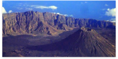
O Parque Natural do Fogo situa-se na zona central da ilha do Fogo e é constituído pelo Vulcão, a Cratera, a Bordeira e o perímetro florestal de Monte Velha. Possui uma área de 8.468,5 hectares e situa-se na confluência dos três municípios da ilha: S. Filipe, Santa Catarina e Mosteiros. O vulcão do Fogo que dá nome à referida ilha possui 2.829 metros, sendo o ponto mais alto de Cabo Verde, e permanece ativo, com uma caldeira de 8 km de diâmetro e abertura para Este.
The Natural Park of Fogo was created by Decree-Law nº3/2003, of 24 February and delimited by Decree-Law nº 3/2008, of 2 June. In this sense, to allow a sustainable management of the park was created and approved the Management Plan through Resolution No. 20/2010 of 19 April.
ler maisThis natural scenery of Chã das Caldeiras, punctuated by an active volcano, has been inhabited and exploited since the first quarter of the 20th century, benefiting mainly from the use of water from the two springs called Fonte Velha and Fonte Nova, located in Boca Fonte, but also from the quality of the soil inside the Caldeiras
It should be noted that Chã das Caldeiras is a unique case of human settlement inside the crater of an active volcano. Volcanic activities that periodically shape the landscape force man and women to adapt to the adversities imposed by nature. In this way, the capacity for resilience is manifested in traditional buildings, such as the funcos, a typical dwelling of Chã das Caldeiras, which is reminiscent of the tribal dwellings of Africa.
O Parque Natural do Fogo – Chã das Caldeiras, uma das maiores áreas protegidas do país, que integra a Rede Nacional de Áreas Protegidas de Cabo Verde, foi inscrito na lista indicativa da UNESCO apoiado nos critérios VIII e X
O Natural Park of Fogo, due to its lithological and geomorphological characteristics, resembles the volcanic islands that make up Macaronesia, and which are located in areas with an extensive history of active volcanism, which constitutes a “hotspot geológico”. In particular, it refers to the Teide Natural Park, Canary Islands, Spain, classified as a World Heritage Site by UNESCO in 2007.
Por serem vulcões testemunhos dos grandes estágios geológicos e geomorfológicos das ilhas atlânticas, tornaram-se espaços de referências de investigação internacional. Igualmente, esta comparação patenteia-se a nível do contraste da paisagem, por um lado, lunar e por outro lado, verdejante numa área relativamente limitada. O aspeto que distingue as duas paisagens resume-se às questões antrópicas, nomeadamente na interação do homem com o meio, que modelou, de uma forma bem marcante, os homens e as mulheres de Chã.
Esta interação ultrapassa o aspeto físico de ocupação do território entrando, após cada erupção, para um plano simbólico onde o vulcão aparece como o ser amigo num complexo equilíbrio apenas compreensível por quem é de Chã das Caldeiras. Esta relação única e singular representa a autenticidade e a originalidade de Chã das Caldeiras.
ler menos

